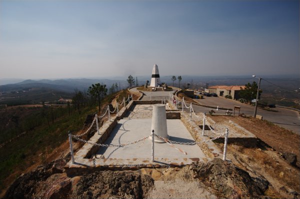
Today I drove from Lisbon to Coimbra via Almourol (a very interesting castle of the Knights of the Temple), Abrantes (a village in Ribatejo which looks like any other village), Vila de Rei and Lousã. I stopped at the geodesical centre of Portugal, which you can see above. The big pilar is the first geodesic mark, marking the first starting point of mapping portugal. It was discovered heroically in 18something. Thank god it was on a hill, else the triangulation would have been tiresome....
The little pilar in front is the geodesic mark TF4, which marks todays starting point of triangulation. At this place next to Vila de Rei there is the most wimpy museum I ever visited (it's for free, else I would be annoyed...). The only things on exhibition are a theodolite, a leveler and a computer with a GPS from Leica. Together with 4 posters on Geodesy, this is the whole museum... If it wouldn't be for the cafeteria, this would loose any reason for existence.

3 comments:
A boring museum about geodesy. Well... I doubt that someone would choose a career in surveying because of the thrill that this job brings, or would he?
compared to the easthall where I am sitting right now it looks/sounds like paradise ...
Actually the only surveyor I know gets around quite a lot, surveying archeoligical sites all around the near and middle east...
Post a Comment